|
(Click for current seismic activity) |
Seismic Monitoring
Global real time seismic activity is available online via the USGS portal. Click on the map to the right to see recent and real-time seismic activity anywhere in the world. Mexico's Servicio Sismologico Nacional also provides a real time map of seismic activity in Mexico. While, the ANZA seismic network provides real time seismic reports in the southern border region of California, the NCEDC network in northern California and the PNSN network in Washington and Oregon. The IRIS consortium also provides an interactive near real time earthquake map as well as a variety of educational materials
Seismic Monitoring in Punta Banda, Baja California
The Science for the People (SfP) seismograph located in Punta Banda is connected to Quake Catcher Network (QCN) hosted at Stanford University. In the event of seismic activity, the location of the SfP seismograph and other relevant seismic sensors participating in the QCN will light up on the QCN Real Time Activity map below and provide an indication of the intensity of the activity registered. The QCN has an open call for more volunteers citizen seismologists ( read more here ) to participate in this system. The more seismographs operating in the Punta Banda region the better we will be able to understand local seismic dynamics. To learn more about the geologic structure, faults, and research in this area click here. If you are local to the Punta Banda region you can contact us and we can assist you with connecting up to the QCN.
Seismic events light up on the map with an indicate the detected intensity.
Select this QCN: Active Sensors and Raw Data Map to verify that the sensor of interest is currently online; to do this one must magnify the sensor map in order to see the Punta Banda region.
Citizen Science and Seismology
The more widely and densely distributed seismographic stations are, the more thoroughly scientists can study the propagation of seismic waves and understand the hazards earthquakes pose to different regions around the world. One way citizens can help scientists understand seismic propagation is by reporting when and where they feel seismic motion. To report seismic activity please see the USGS "Did you Feel it" portal. The Quake Catcher network based at Stanford University but representing a collaboration of many universities is calling for citizen volunteers to share the data they can collect from their laptop accelerometers (used to detect impacts.) The QCN has also made relatively accurate and relatively cheap USB based seismographs available for ~$50.00 US dollars. By enlisting citizen volunteers to buy and implement these accelerometers to track seismic activity in many locations scientists and citizens are revolutionizing data collection within seismology11.
Exemplar O-NavB sensor record data (Punta Banda; Oct 24, 212)

|
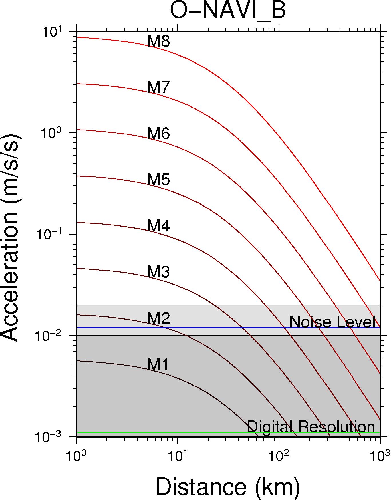
Equipment Detail
Science for the People is hosting the O-NavB digital seismograph produced by QCN. The following graph provides details of its resolution and noise floor.