
|
|
|
|
|
|
|
Plate Tectonic Theory, Seismology, and Earthquakes
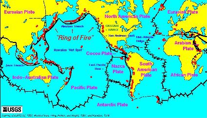
Renowned for the devastation that they can bring by suddenly opening deep crevices in the ground, shaking buildings until they collapse, and generating tsunamis that terrorize coastal populations, earthquakes seem to be able to strike anywhere... and at anytime. Although earthquakes are unpredictable in time; they tend to be geographically localized. Mapping earthquake epicenters over time (see top left image) reveals dense clusters of seismic activity in what are now known to be the boundaries between the crustal plates of the Earth.
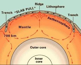
The relatively thin rigid rocky plates that form the crustal surface of the planet are buoyed up and driven by convective currents in the hot softened rock of the mantle that underlie them (see animation). The decay of radioactive isotopes within Earth's Mantle and core generate tremendous heat and pressure causing the liquid rock to expand upwards, pushing magma out through cracks and weak points in the crust. Most of the hot upwelling mantle material emerges in the great ranges of underwater volcanos known as mid-oceanic ridge system . As these newly fromed mountains of lava cool in ocean waters they forms new crustal material and expand the area of the the oceanic plates. This phenomeon of sea-floor spreading drives neighboring plates into one another. Ultimately some of the rustal material at the plate boundaries back down into the mantle (in a process called subduction) while thrusting other crustal material upwards forming mountain ranges. GPS based studies indicate the velocity of the various tectonic plates are typically less than 60 mm/year.
In the collision, scraping, and sliding of one tectonic plate with another, enormous pressure can build up over many years and then be released suddenly. This sudden shift is an earthquake, which generates seismic waves that propagate through the surface and the bulk of the planet wreaking havoc on human constructions.
Maps of seismic activity reveal that the vast majority of deep earthquakes occur along the "Ring of Fire" which encircles the Pacific Plate and runs along the east coast of Asia and the west coast of North and South America. These deep earthquakes are triggered as the Pacific plate subducts underneath neighboring continental plates. The study and monitoring of seismic activity is key to understanding earthquakes, the possible development of earthquake early warning systems (likely no more than seconds), verification of the Comprehensive Nuclear Test Ban Treaty (CNTB) and also allows scientists to study internal features of the planet in a manner analogous to ultrasound imaging.
Select Map: Baja California |
Tectonic Structure Baja California, Mexico
In general terms, Baja California and most of the west coast of California lie on the eastern rim of the Pacific Plate while the bulk of the Continental US and Mexico lie on the western border of the North American Plate. The San Andreas fault system which generally runs north and south separates coastal California from the rest of the state. For the most part the San Andreas is a transform fault system, as the predominant motion of the two plates is of sliding past one another. Relative to the North American plate, the Pacific plate is subducting and heading north at a rate of about 35 mm/year 12.
Just north of Baja and near the southern edge of California the San Andreas "bends", trends east and then south into the Gulf of California (GC). The GC represents an important transition in the fault system; in the gulf the Pacific plate and the North American plates are not simply sliding past one another, they are pulling apart. This divergent boundary rift system connects to the global oceanic ridge system. The tectonic movement here formed the GC and separated Baja California from the North American plate. Due to the complex fracturing dynamics of the plates in this region and the heavily populated coastline of the south-western seaboard of North America and Baja Norte, the region receives intensive scientific study 13, 14, 15, 16, 17, 18, 19, 20, 21, 22, 23, 24, 25 20, .
Tectonic structure of Northern Baja, Ensenada, and Punta Banda
Detailed studies and maps of the fault system of California and Baja California (BC) reveal that the great San Andreas system is comprised of many smaller fault zones. The rifting in the Gulf of California (GC) is similarly complex. Baja California as a whole is moving northwards with the Pacific plate; however BC Norte also hosts some transverse faults, notably the Aqua Blanca fault just south of Ensenada. As can be seen in the collection of maps below, the Aqua Blanca Fault (ABF) lines fall within and on either side of the Punta Banda Peninsula. Although evidence suggests significant movement along the ABF in the past, current estimates suggest a rate of about 6 mm/year. Along with other transpeninsular fault lines, the Aqua Blanca is and remains an area of active seismic research which is one more reason for locals to consider engaging in some citizen seismology.
Select Map: Punta Banda Ensenada BC Norte GC Norte GC BC California |
Earthquakes
The seismicity and hazard maps featured below allow one to estimate the risk of experiencing strong earthquakes in the regions of the US, Mexico, Baja, Ensenada, and Punta Banda. Risk maps also make it clear that no area is entirely safe from earthquakes or the strife due to earthquakes that might occur elsewhere. From 1980 to 2012, estimates of the annual number of deaths due to earthquakes has ranged from a low of 174 in 1984 to a high of 320,120 in 2010. The mean number of people who die due to earthquakes is about 29,000 per year or 80 per day. With the human population density continuing to increase fatalaties due to earthquake fatalities are projected to rise as well. How one and one's community prepare for and behave behave during an earthquake are the only means of protecting against them 26, 27, 28, 29, 30, 31, , . In relatively remote areas, residents should consider not just the immediate impact of earthquakes but also be prepared to deal with delays in the arrival of support from outside sources. Potable water and first aid supplies are of particular interest in semi-arid and relatively isolated environments such as Punta Banda.
Select Map: Seismic Hazard Seismicity (1900-) Sismicidad 2012 |
Partial List of References (still under construction)
The San Andreas Fault (44:00)
The Ring of Fire (43:00)
The "Golden" state and mountain formation in CA (44:00)
UCSD's Earthguide Onine Classroom
USGS National Geologic Map Database
USGS Earthquake Facts and Statistics Graphs
Earthquake Catastrophes and Fatalities Projected to Rise in Populous 21st Century